

![Image [1]-Agricultural Mapping Drone-msoen](https://www.msoen.com/wp-content/uploads/2026/01/b0b3024095195152-768x1024.jpg)
![Image [2]-Agricultural Mapping Drone-msoen](https://www.msoen.com/wp-content/uploads/2026/01/5ced0788d4195152-768x1024.jpg)
![Image [3]-Agricultural Mapping Drone-msoen](https://www.msoen.com/wp-content/uploads/2026/01/e46bda83bc195152-1024x768.jpg)
![Image [4]-Agricultural Mapping Drone-msoen](https://www.msoen.com/wp-content/uploads/2026/01/205cf97c91195220-838x1024.jpg)
![Image [5]-Agricultural Mapping Drone-msoen](https://www.msoen.com/wp-content/uploads/2026/01/cf212fb489195220-768x1024.jpg)
![Image [6]-Agricultural Mapping Drone-msoen](https://www.msoen.com/wp-content/uploads/2026/01/529a7ff665195152-768x1024.jpg)
Introduction
Modern agriculture is rapidly evolving as farmers adopt advanced technologies to increase productivity, reduce costs, and improve decision-making. One of the most important innovations in precision agriculture is the agricultural mapping drone. This specialized drone is designed to capture high-resolution aerial data that helps farmers analyze their fields, monitor crop health, and plan more efficient farming operations.
Traditional farm monitoring methods rely heavily on manual field inspection, satellite images, or outdated maps. These methods can be slow, expensive, and sometimes inaccurate. In contrast, agricultural mapping drones provide fast, accurate, and detailed aerial data that allows farmers to make better management decisions.
From large commercial farms to agricultural cooperatives and research institutions, mapping drones are becoming an essential tool for modern farming. They help farmers understand field conditions, detect problems early, and apply precision agriculture strategies that improve crop yield and reduce resource waste.
For agricultural businesses, drone service providers, and distributors, agricultural mapping drones also represent a growing market opportunity with strong demand worldwide.
What Is an Agricultural Mapping Drone
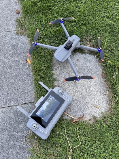
An agricultural mapping drone is an unmanned aerial vehicle designed to collect aerial images and geographic data over farmland. The drone flies over agricultural fields while capturing high-resolution images using specialized cameras and sensors. These images are then processed with mapping software to create detailed maps and data models.
Agricultural mapping drones are typically equipped with several advanced technologies:
- High-resolution RGB cameras
- Multispectral or NDVI sensors
- GPS or RTK positioning systems
- Autonomous flight planning software
- Long-range communication systems
- High-efficiency propulsion systems
These technologies enable the drone to collect precise data about farmland conditions, crop growth, soil variation, and field boundaries.
Why Farmers Need Agricultural Mapping Drones
Accurate Field Data
One of the biggest challenges in farming is understanding the real conditions of large fields. Walking through hundreds of hectares of farmland to inspect crops manually is time-consuming and often incomplete.
Mapping drones provide accurate aerial images of the entire farm within a short time.
Early Detection of Crop Problems
Agricultural drones can identify crop stress, disease, pest infestations, and irrigation issues before they become visible to the human eye.
Early detection allows farmers to respond quickly and prevent yield loss.
Improved Farm Planning
Drone-generated maps help farmers plan planting patterns, irrigation systems, and fertilizer application strategies more effectively.
Precision Agriculture
By analyzing field data collected by drones, farmers can apply fertilizers and pesticides only where needed. This reduces costs and improves environmental sustainability.
How Agricultural Mapping Drones Work
The operation of an agricultural mapping drone involves several steps.
First, the operator defines the mapping area using drone flight planning software. The boundaries of the farmland are marked on a digital map.
Next, the drone automatically generates an optimized flight route that ensures complete coverage of the field.
Once launched, the drone follows the programmed route while capturing aerial images at regular intervals.
After the flight is completed, the captured images are processed using specialized mapping software. The software stitches the images together to create detailed maps such as:
- Orthomosaic maps
- 3D terrain models
- Vegetation health maps
- Field boundary maps
These maps provide valuable insights for farm management.
Types of Data Collected by Agricultural Mapping Drones
Agricultural mapping drones can collect different types of data depending on the sensors installed.
RGB Imaging
Standard RGB cameras capture high-resolution color images of farmland. These images help farmers observe crop growth patterns, field conditions, and infrastructure.
Multispectral Imaging
Multispectral sensors capture data beyond the visible spectrum. This allows farmers to analyze plant health using vegetation indices such as NDVI.
Crop Health Monitoring
By analyzing multispectral data, farmers can detect areas where crops are stressed due to pests, disease, nutrient deficiency, or water shortage.
Field Topography
Mapping drones can create 3D terrain models that show the elevation and slope of farmland. This information is useful for irrigation planning and soil management.
Applications of Agricultural Mapping Drones
Agricultural mapping drones are widely used across many farming sectors.
Crop Health Monitoring
Farmers use mapping drones to monitor crop growth and detect problems early.
Precision Fertilization
Drone data helps identify areas of nutrient deficiency so fertilizers can be applied more precisely.
Irrigation Planning
Field elevation data allows farmers to design efficient irrigation systems.
Pest and Disease Detection
Mapping drones can detect abnormal crop patterns that indicate pest infestations or disease outbreaks.
Land Surveying
Agricultural drones provide accurate maps for land measurement, farm planning, and field boundary identification.
Benefits of Agricultural Mapping Drones
Faster Data Collection
A mapping drone can survey hundreds of hectares of farmland in a single day.
High Accuracy
Advanced GPS and RTK systems allow drones to collect highly accurate geographic data.
Reduced Labor
Drone mapping replaces time-consuming manual field inspections.
Better Decision Making
Accurate field data allows farmers to make informed decisions that improve productivity.
Lower Farming Costs
Precision agriculture techniques reduce waste of fertilizers, pesticides, and water.
Advantages Over Satellite Imagery
While satellite images are commonly used for agricultural monitoring, drones offer several advantages.
Higher Resolution
Drone images are much clearer and more detailed than satellite images.
Flexible Scheduling
Farmers can fly drones whenever they need updated field data, rather than waiting for satellite passes.
Weather Independence
Drones can operate below cloud cover, while satellites may be blocked by clouds.
Real-Time Results
Drone data can be processed quickly, providing farmers with near real-time information.
Key Features of Professional Agricultural Mapping Drones
Long Flight Time
High-performance mapping drones offer long endurance flights, allowing them to survey large areas efficiently.
Stable Flight Performance
Advanced flight controllers ensure stable flight even in windy agricultural environments.
High-Precision GPS
RTK positioning technology improves mapping accuracy and ensures reliable data collection.
High-Resolution Cameras
Professional cameras capture detailed aerial images required for precise mapping.
Automated Flight Planning
User-friendly software allows operators to create flight routes easily and automate the entire mapping mission.
Economic Value for Farmers and Agribusiness
Agricultural mapping drones provide significant economic benefits.
Increased Crop Yield
Early detection of crop issues helps farmers protect yields and maintain crop health.
Reduced Input Costs
Precision agriculture reduces unnecessary fertilizer and pesticide usage.
Better Farm Management
Detailed maps allow farmers to plan operations more efficiently.
Competitive Advantage
Farmers using drone technology can adopt modern farming practices that increase productivity and sustainability.
Business Opportunities in Agricultural Drone Mapping
The agricultural drone mapping industry is growing rapidly, creating opportunities for entrepreneurs and agricultural companies.
Possible business models include:
- Agricultural drone surveying services
- Precision farming consulting
- Agricultural drone equipment sales
- Drone data analysis services
As more farms adopt precision agriculture technologies, demand for drone mapping services continues to increase.
Choosing the Right Agricultural Mapping Drone
When selecting a mapping drone for agriculture, several important factors should be considered.
Camera Quality
High-resolution cameras provide more detailed mapping results.
Flight Endurance
Longer flight time allows the drone to cover larger fields per mission.
Positioning Accuracy
RTK GPS improves mapping precision.
Data Processing Compatibility
The drone should work with professional mapping software platforms.
Durability
Agricultural drones must withstand dust, wind, and frequent outdoor use.
Future Trends in Agricultural Mapping Drones
Agricultural mapping drones continue to evolve with new technologies that enhance farm management.
Future developments may include:
- AI-powered crop health analysis
- Real-time drone data processing
- Integration with automated farm machinery
- Swarm drone mapping systems
- Smart agriculture platforms connected to drone data
These innovations will further expand the role of drones in precision agriculture.
Conclusion
The agricultural mapping drone is transforming modern farming by providing accurate aerial data that helps farmers understand their fields like never before. With high-resolution imaging, intelligent flight planning, and powerful data analysis capabilities, mapping drones enable farmers to adopt precision agriculture strategies that improve productivity and reduce costs.
From crop monitoring and soil analysis to irrigation planning and land surveying, agricultural mapping drones provide valuable insights that support better decision-making across the entire farming operation.
For farmers, agricultural service providers, and drone distributors looking to stay competitive in the modern agricultural industry, investing in agricultural mapping drone technology is a strategic step toward smarter and more efficient farming.




No comments yet