

![Image [1]-Best Drone for Rural Area: Msoen AgriView 4K for Farmland Surveying, Mapping & Scenic Shots-msoen](https://www.msoen.com/wp-content/uploads/2025/12/aa3f1b38c9203751-768x1024.jpg)
![Image [2]-Best Drone for Rural Area: Msoen AgriView 4K for Farmland Surveying, Mapping & Scenic Shots-msoen](https://www.msoen.com/wp-content/uploads/2025/12/c134edd9b8203751-768x1024.jpg)
![Image [3]-Best Drone for Rural Area: Msoen AgriView 4K for Farmland Surveying, Mapping & Scenic Shots-msoen](https://www.msoen.com/wp-content/uploads/2025/12/705be9ca8a203751-768x1024.jpg)
![Image [4]-Best Drone for Rural Area: Msoen AgriView 4K for Farmland Surveying, Mapping & Scenic Shots-msoen](https://www.msoen.com/wp-content/uploads/2025/12/47dc5571e6203750-768x1024.jpg)
![Image [5]-Best Drone for Rural Area: Msoen AgriView 4K for Farmland Surveying, Mapping & Scenic Shots-msoen](https://www.msoen.com/wp-content/uploads/2025/12/6f55cfd782203343-768x1024.jpg)
![Image [6]-Best Drone for Rural Area: Msoen AgriView 4K for Farmland Surveying, Mapping & Scenic Shots-msoen](https://www.msoen.com/wp-content/uploads/2025/12/a2749201af203343-768x1024.jpg)
![Image [7]-Best Drone for Rural Area: Msoen AgriView 4K for Farmland Surveying, Mapping & Scenic Shots-msoen](https://www.msoen.com/wp-content/uploads/2025/12/a6d15c5d90203343-768x1024.jpg)
![Image [8]-Best Drone for Rural Area: Msoen AgriView 4K for Farmland Surveying, Mapping & Scenic Shots-msoen](https://www.msoen.com/wp-content/uploads/2025/12/8bd3d721bf203751-768x1024.jpg)
In the vast stretches of countryside, where rolling hills meet open fields and winding rivers carve through the land, a new kind of tool is transforming how we see, manage, and share rural life. Drones—once seen as gadgets for urban tech lovers—are now proving indispensable for farmers, landowners, agronomists, and rural filmmakers.
If you’re looking for the best drone for rural area use, especially for tasks like crop monitoring, boundary mapping, livestock tracking, or capturing breathtaking aerial views of farmland, then you’ve come to the right place. In this in-depth guide, we’ll explore why a purpose-built rural drone is essential, what features to look for, and why the Msoen AgriView 4K stands out as the most reliable solution for countryside operations.
Whether you’re managing hundreds of acres or simply want to document the changing seasons on your family farm, this article will help you choose the right aerial tool for the job.
Why Drones Are Revolutionizing Rural Work
Rural areas present unique challenges: large, open spaces; limited infrastructure; variable terrain; and unpredictable weather. Traditional methods of land inspection—walking fields, driving ATVs, or hiring manned aircraft—are time-consuming, costly, and often imprecise.
Drones solve these problems by offering:
- Fast Coverage: Inspect 50+ acres in under 30 minutes.
- High-Resolution Imaging: Spot crop disease, irrigation issues, or pest damage early.
- Cost Efficiency: Eliminate the need for planes or helicopters.
- Accessibility: Reach remote corners of a property without building roads.
- Data-Driven Decisions: Use maps and thermal data to optimize yields.
From surveying fence lines to filming harvest festivals, drones bridge the gap between tradition and technology in the countryside.
Key Challenges of Flying Drones in Rural Areas
Before choosing a drone, it’s important to understand the realities of rural flight:
| Challenge | Impact |
|---|---|
| Weak Cellular Signals | Limits reliance on cloud apps; requires offline features |
| Large Open Spaces | Risk of losing visual contact; need long-range control |
| Variable Wind Gusts | Demands stable flight and strong motors |
| Limited Charging Points | Requires long battery life and solar charging options |
| Wildlife Interference | Birds, livestock may react unpredictably |
That’s why a rural drone must be more than just a camera in the sky—it must be durable, intelligent, and self-reliant.
Must-Have Features in a Drone for Countryside & Farmland
When selecting a drone for rural use, prioritize these capabilities:
1. Long Flight Time
Rural areas often span hundreds of acres. Look for a drone that offers at least 25–35 minutes of flight time per battery.
2. Extended Control Range
A range of 2–3 km ensures you can cover distant fields without losing connection.
3. High-Resolution Camera
4K video and 12MP+ stills are essential for identifying plant health, soil patterns, or structural damage.
4. GPS with Return-to-Home
Accurate GPS prevents drift and ensures the drone returns safely if the signal weakens.
5. Obstacle Avoidance
While less critical in open fields, sensors help when flying near barns, trees, or power lines.
6. Offline Functionality
In areas with no internet, the drone and controller should work independently.
7. Weather Resistance
Dust, rain, and light wind shouldn’t ground your operations.
Introducing the Msoen AgriView 4K – Built for the Fields
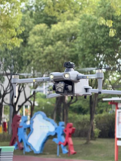
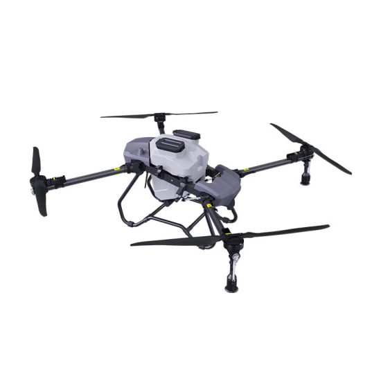
The Msoen AgriView 4K is a rugged, purpose-built drone designed specifically for rural, agricultural, and countryside applications. Whether you’re monitoring crops, inspecting fences, or filming a documentary about rural life, this drone delivers professional results with farmer-friendly simplicity.
Why the Msoen AgriView 4K?
1. 4K Camera with Adjustable Gimbal
Capture razor-sharp 4K video and 20MP stills with a 3-axis mechanical gimbal. The camera tilts from -90° to +30°, allowing you to shoot straight down for field analysis or forward for panoramic views of valleys and ridges.
2. 35-Minute Flight Time
Powered by a high-capacity 5200mAh battery, the AgriView 4K flies up to 35 minutes per charge—longer than most drones in its class. Two batteries are included, giving you over an hour of continuous flight.
3. 3km Extended Transmission Range
With OcuSync 2.0 technology, the AgriView maintains a stable connection up to 3 kilometers away. Even in low-signal areas, you stay in control.
4. Dual-GPS + RTK Support (Optional)
Standard GPS and GLONASS provide rock-solid positioning. For survey-grade accuracy, an optional RTK module is available, enabling centimeter-level mapping.
5. Rugged, All-Weather Design
The body is made from impact-resistant polycarbonate and aluminum alloy. It resists dust, light rain, and temperatures from -10°C to 40°C—perfect for early mornings and late harvests.
6. Intelligent Flight Modes
Save time and effort with:
- FieldScan Grid: Automatically maps rectangular plots.
- Boundary Trace: Follows property lines using GPS.
- Topographic Mode: Captures elevation changes.
- Time-Lapse Farming: Shows crop growth over weeks.
- Follow Me: Tracks you on a tractor or ATV.
All modes are accessible via the Msoen FieldPilot app, which works offline.
7. Livestock & Wildlife Monitoring
The drone’s quiet brushless motors and high-altitude hover make it ideal for observing animals without causing distress.
8. No Subscription Required
Unlike some commercial drones, the AgriView 4K doesn’t require monthly fees for basic functions.
Technical Specifications
| Feature | Details |
|---|---|
| Weight | 680g |
| Dimensions (Folded) | 18 × 11 × 6 cm |
| Camera | 4K UHD @ 30fps / 20MP stills |
| Gimbal | 3-axis mechanical, ±0.01° stability |
| Max Flight Time | 35 minutes per battery |
| Max Range | 3 km (unobstructed) |
| Transmission | OcuSync 2.0 (5GHz + 2.4GHz) |
| GPS | GPS + GLONASS (RTK optional) |
| Max Wind Resistance | 10.5 m/s (Level 5) |
| Operating Temperature | -10°C to 40°C |
| Internal Storage | 64GB (no card needed) |
| Expandable Storage | microSD up to 512GB |
| Battery Type | 2x 5200mAh Li-Po |
| Remote Control | Included (OLED display, no phone needed) |
| Software | Msoen FieldPilot (iOS/Android) |
Common Rural Applications of the Msoen AgriView 4K
1. Crop Health Assessment
Use the 4K camera to identify uneven growth, yellowing patches, or irrigation gaps. Early detection saves thousands in lost yield.
2. Land Surveying & Mapping
Create accurate 2D and 3D maps of your property. The optional RTK module ensures boundaries are exact—useful for fencing, zoning, or selling land.
3. Fence & Infrastructure Inspection
Check miles of fencing, irrigation pipes, or solar panels without leaving your vehicle.
4. Livestock Management
Locate missing cattle, count herds, or monitor grazing patterns from above.
5. Seasonal Documentation
Film planting in spring, blooming in summer, and harvesting in fall. Create time-lapses that tell the story of your land.
6. Rural Event Filming
Capture weddings, county fairs, barn dances, or sunrise over wheat fields—all in cinematic 4K.
How It Compares to Other Drones
| Model | Flight Time | Camera | GPS | Range | Rural-Ready? |
|---|---|---|---|---|---|
| Msoen AgriView 4K | 35 min | 4K + Gimbal | Yes | 3 km | ✅ Yes |
| Consumer Drone A1 | 25 min | 2.7K | Yes | 1.5 km | ❌ Limited |
| Hobby Drone B2 | 18 min | 1080p | No | 800m | ❌ No |
| Commercial Drone C3 | 40 min | 4K | Yes | 5 km | ✅ Yes ($1,500+) |
The AgriView 4K hits the sweet spot: professional features at a practical price.
Tips for Flying Drones on Farms & Rural Properties
- Plan Your Route: Use offline maps to mark waypoints before takeoff.
- Fly During Calm Hours: Early morning or dusk reduces wind interference.
- Mark No-Fly Zones: Avoid areas near airports, homes, or livestock pens.
- Carry Spare Parts: Extra propellers and a mini toolkit save the day.
- Label Your Drone: Attach contact info in case it lands in a neighbor’s field.
Always register your drone if required by local law (most countries mandate registration for drones over 250g).
Maintenance for Year-Round Reliability
- Clean the camera lens after dusty fieldwork.
- Dry rotors after rain exposure.
- Store batteries at 50% charge during winter.
- Update firmware quarterly via the FieldPilot app.
- Inspect motors annually for debris buildup.
With care, the AgriView 4K will serve you season after season.
Customer Stories from the Field
“I manage 300 acres of corn and soy. The AgriView lets me scout the whole farm in under an hour—something that used to take two days on foot.” – Tom R., Iowa
“We filmed our county’s 150th anniversary parade with it. The 4K footage looked like a movie.” – Linda K., Vermont
“Finally, a drone that doesn’t freeze up when there’s no cell service.” – Carlos M., Montana
Final Verdict: Is the Msoen AgriView 4K Right for You?
If you work or live in a rural area—whether as a farmer, rancher, landowner, or filmmaker—the Msoen AgriView 4K is the most versatile and dependable drone you can buy under $400.
You get:
- A true 4K camera with mechanical stabilization
- Over half an hour of flight time
- 3km range for covering large properties
- Rugged build that handles farm conditions
- Offline operation—no internet needed
- No hidden subscription fees
It’s not just a toy. It’s a working tool for the modern countryside.
Get Started Today
The land tells a story. With the Msoen AgriView 4K, you can finally see it from above.
Order now and receive:
- Free shipping
- 2 batteries + dual charger
- Hard-shell carrying case
- 1-year warranty
- Lifetime technical support
No matter where your land lies—on a windswept prairie, a misty valley, or a sunbaked hillside—this drone is ready to fly.
Frequently Asked Questions
Q: Can I fly it in areas with no cell service?
A: Yes. The controller and app work fully offline. Maps can be pre-downloaded.
Q: Is it hard to learn?
A: No. The FieldPilot app includes interactive tutorials and one-touch takeoff/landing.
Q: Can it detect crop diseases?
A: While it doesn’t diagnose diseases, the high-res imagery helps you spot symptoms early for expert analysis.
Q: What if it lands in a crop field?
A: The Return-to-Home function brings it back to the last known position. The low-noise design minimizes disturbance.
Q: Does it work in cold weather?
A: Yes, down to -10°C. Batteries perform best when warmed, so store them indoors before use.
Thank you for reading our complete guide to the best drone for rural area use. If you’re ready to bring your land into focus—from the sky down—the Msoen AgriView 4K is your trusted partner.
Fly high. Farm smart. See farther. 🚁



No comments yet