
![图片[1]-Precision Farming Drones: Elevating Agricultural Efficiency with UAV Technology-msoen](https://www.msoen.com/wp-content/uploads/2025/04/2caef68db4184641-768x1024.jpg)
Introduction
In the era of data-driven agriculture, precision farming drones have become indispensable tools for growers seeking to maximize yields, reduce inputs, and manage resources sustainably. By combining advanced sensors, GPS/RTK navigation, and intelligent flight planning, these unmanned aerial vehicles (UAVs) enable farmers to make real-time decisions based on accurate field data. This article explores how precision farming drones work, their key benefits, and best practices for integration into modern crop management systems.
What Is a Precision Farming Drone?
A precision farming drone is a specialized UAV equipped with:
- Multispectral/NDVI cameras: Capture near-infrared and visible light to assess plant health.
- Thermal sensors: Detect temperature variations indicating water stress or disease.
- GPS/RTK modules: Ensure centimeter-level flight accuracy for repeatable scouting routes.
- Automated flight software: Allows pre-programmed mission planning and autonomous waypoint navigation.
- Data-management platform: Integrates aerial imagery with farm management systems for actionable insights.
Core Applications
- Crop Health Monitoring
Regular flights generate vegetation index maps (NDVI, EVI) to identify nutrient deficiencies, pest outbreaks, and disease early. - Variable-Rate Application
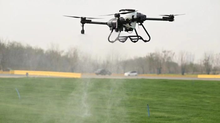
Prescription maps derived from drone data guide variable-rate sprayers or spreaders for fertilizers, pesticides, and water, optimizing input use. - Soil Moisture & Irrigation Management
Thermal imaging highlights dry zones, enabling targeted irrigation and reducing water waste. - Field Mapping & Planning
High-resolution orthomosaics create accurate field boundaries, elevation models, and planting plans. - Yield Estimation & Forecasting
Biomass and canopy measurements help predict harvest volumes, inform market planning, and manage storage logistics.
Key Benefits
- Resource Efficiency
Reduce fertilizer, pesticide, and water usage by up to 30% through targeted treatment. - Labor Savings
Automate routine scouting and mapping tasks, freeing personnel for high-value work. - Faster, Data-Driven Decisions
Receive near-instant field diagnostics to adjust inputs or deploy treatments before problems escalate. - Environmental Sustainability
Minimize chemical runoff and soil compaction with aerial applications and precise ground coverage. - Scalability
Suitable for small family farms to large commercial operations—multiple drone fleets can cover thousands of acres per day.
Features to Evaluate When Selecting a Precision Farming Drone
| Feature | Why It Matters |
|---|---|
| Sensor Suite | NDVI + thermal cameras for multi-layer analysis |
| Flight Time & Range | Determines area coverage per battery |
| Navigation Accuracy | RTK support ensures repeatable flight lines |
| Data Integration | Compatibility with GIS and farm-management software |
| Autonomy & Obstacle Avoidance | Reduces pilot workload and increases safety |
| Durability & Weatherproofing | Allows operation in varied field conditions |
Best Practices for Deployment
- Regular Flight Scheduling
Conduct weekly or bi-weekly missions during critical growth stages (e.g., post-emergence, flowering). - Standardized Data Naming & Storage
Organize imagery and reports with date, field name, and sensor type for easy retrieval. - Cross-Validation with Ground Truthing
Periodically sample soil and plant tissue to verify aerial data accuracy. - Operator Training & Certification
Ensure pilots are certified and follow local UAV regulations and safety protocols. - Collaborate with Agronomists
Combine drone insights with expert recommendations to fine-tune input schedules.
Integrating Drones into Your Farm Management System
- Connect to Cloud Platforms: Upload flight logs and imagery to services that offer AI-driven analytics.
- Generate Prescription Maps: Export variable-rate files compatible with GPS-enabled tractors and sprayers.
- Monitor ROI Metrics: Track input savings, yield improvements, and time saved to justify technology investment.
Future Trends
- AI & Machine Learning: Autonomous disease and weed recognition for even faster response times.
- Swarm Technology: Coordinated fleets of smaller drones working in unison to cover larger areas more efficiently.
- Edge Computing: On-board processing to deliver near-instant analytics without cloud dependence.
- Regulatory Harmonization: Simplified BVLOS (Beyond Visual Line of Sight) approvals for commercial agricultural use.
Conclusion
Precision farming drones represent a leap forward in agricultural technology, providing growers with detailed insights and control over every acre. By leveraging high-resolution sensors, accurate navigation, and integrated data platforms, these UAVs help farmers optimize inputs, boost yields, and operate sustainably. Adopting precision farming drones today paves the way for a more productive and environmentally responsible tomorrow.

暂无评论内容